This tutorial uses SurrealDB to find where a drone is from the photos it takes, without satellite navigation, and then to steer it to a destination while it stays out of a restricted country. It combines vector search and geospatial queries in the same statements, and it is for readers who know basic SurrealQL and want to see the two features work together.
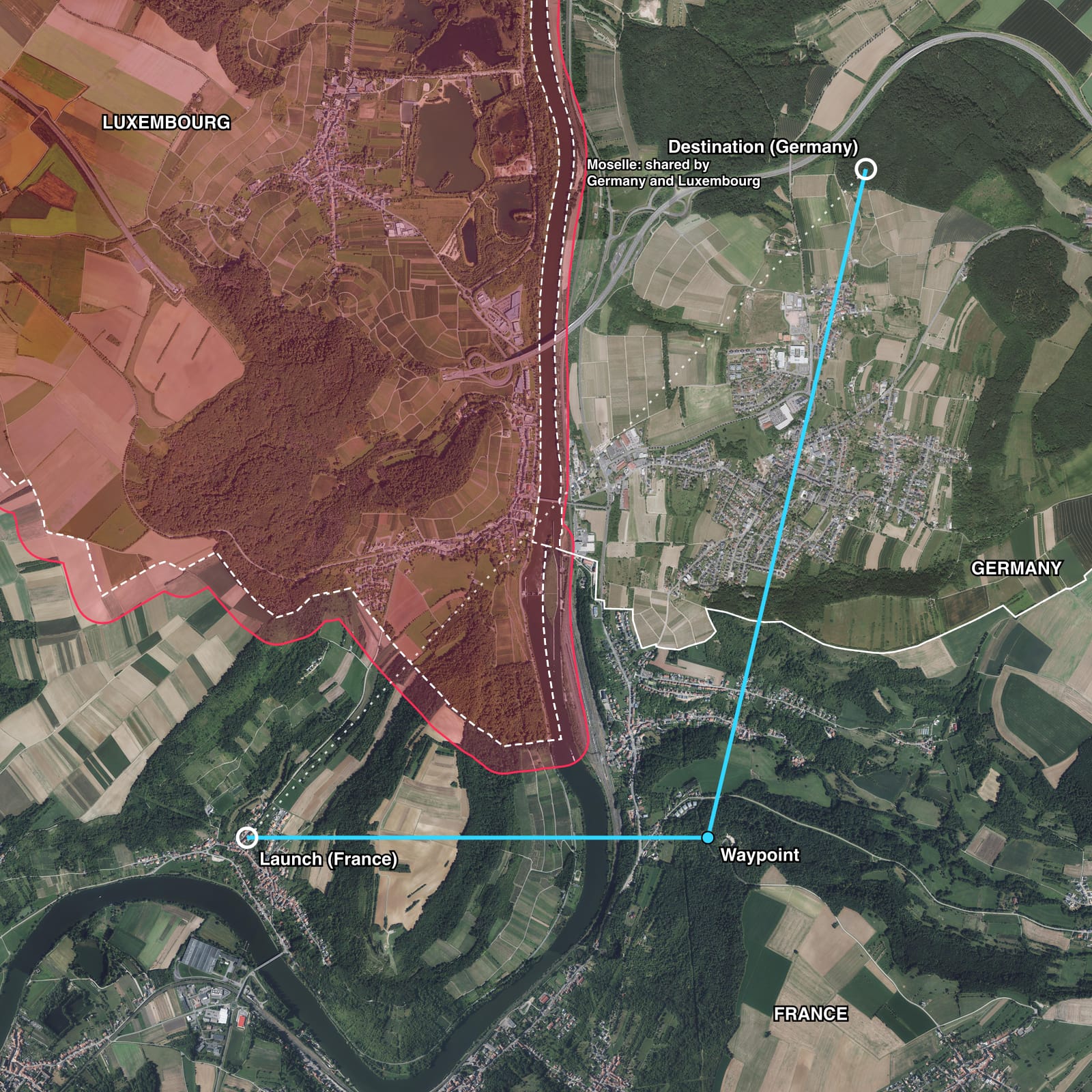
Satellite navigation signals can be jammed or spoofed. A drone with a downward camera can still compare each photo with a map of aerial images it carries, and the closest match gives its position. Vector search finds the match. Geospatial queries make the match reliable, and then answer the navigation questions: which country the drone is in, how far it is to the destination, which direction to fly, and whether the straight route crosses a no-fly zone.
When you finish, you will have run each of those queries on the data from a simulated flight over real imagery.
How the demo works
The demo has three parts, and SurrealDB answers every question in each part with one query.
| Part | Question | SurrealQL |
|---|---|---|
| Locate | Which map tile looks most like this photo? | A KNN search on an HNSW index |
| Narrow the search | Which tiles can the drone have reached? | geo::distance() in the same WHERE clause |
| Navigate | Which country, how far, which way, is it clear? | INSIDE, geo::distance(), geo::bearing(), INTERSECTS |
To compare a photo with the map, the drone does not compare pixels. An image model turns each picture into an embedding: a list of numbers that describes what the picture shows. Two pictures of the same fields, roads and woods give embeddings that point in nearly the same direction, even when the light, the season or the angle differs. A search for the nearest embeddings is therefore a search for the most similar pictures.
On a real drone, the drone's software passes two kinds of value to the database, which runs on the drone itself (see Run SurrealDB on the drone): the embedding of each photo, and its positions and routes as geometry values. Every SurrealDB SDK has geometry types, so a client can send a point or a line as a geometry. Before SurrealDB 4.0, send them this way: a geometry operator such as INSIDE answers false for a plain GeoJSON object rather than raising an error. From 4.0, the operators read a GeoJSON object as the geometry it describes, so either form works. In this tutorial the photos are already stored in the dataset, so each query reads them from there.
Requirements
SurrealDB 3.3 or later. The queries on this page were run on SurrealDB 3.3.4 and 4.0. The
SPATIALindex in step 3 needs SurrealDB 4.0.The Surreal CLI, to start a database and import the dataset.
The area and the mission
The demo flies around the point where France, Germany and Luxembourg meet, on the river Moselle beside the village of Schengen. The area is a square of 6 × 6 km centred on that point. It holds vineyards, villages, forest, a motorway bridge and the river, so neighbouring parts of the map look different from each other in most places.
The drone has a flight plan: it starts in France and must reach a destination in Germany. It has no permission to enter Luxembourg, so its route must stay out of Luxembourg's airspace, even though the straight line from the start to the destination crosses it.
Each country's border is a polygon: a closed line of points, with a straight edge between each pair. Real borders follow rivers, roads and field boundaries, so these polygons have many points. The demo joins the municipal boundaries from OpenStreetMap for each country, which gives a polygon that reaches beyond the edge of the imagery:
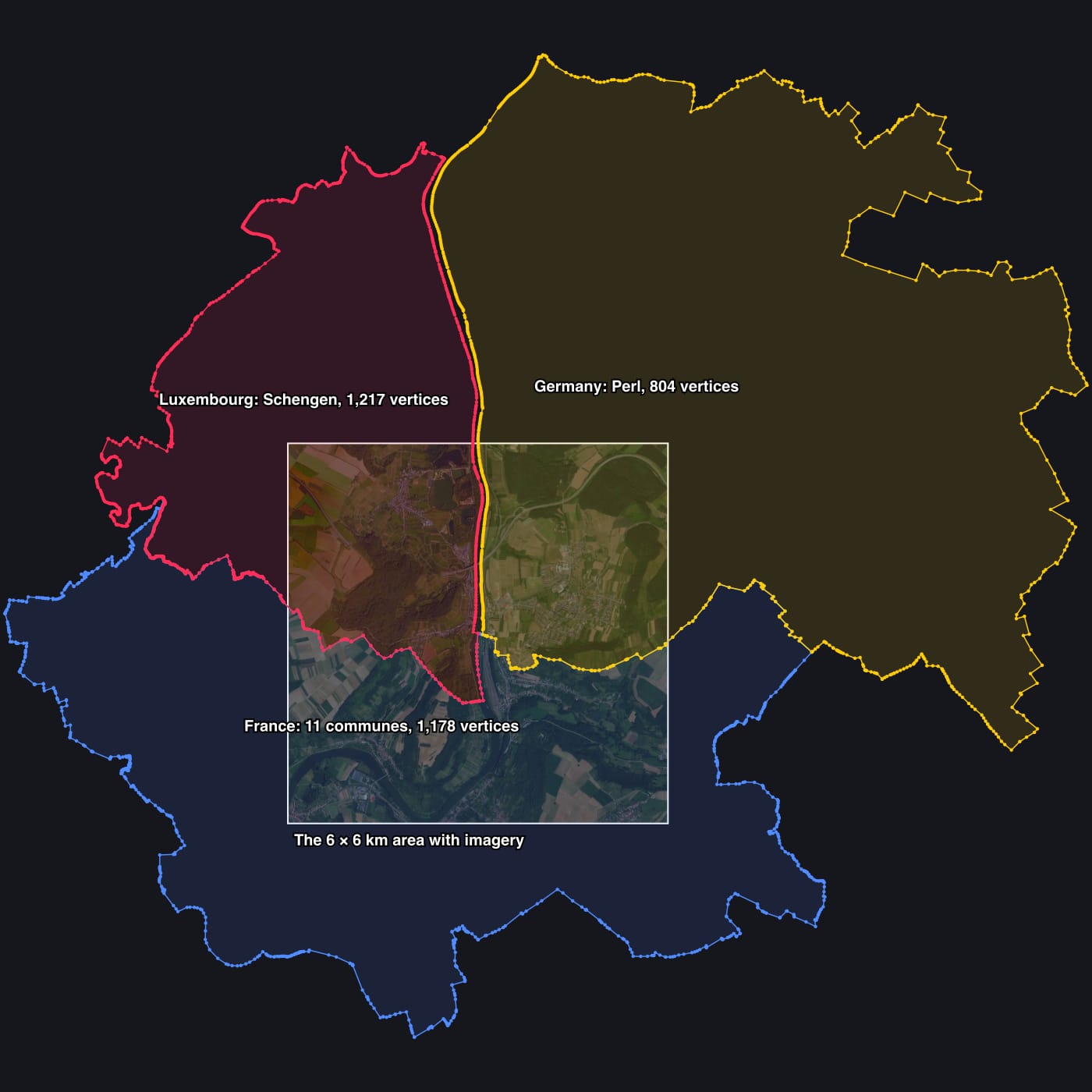
| Country | Joined from | Vertices |
|---|---|---|
| France | 11 communes | 1,178 |
| Luxembourg | Schengen | 1,217 |
| Germany | Perl | 804 |
The area also holds one detail that a border check must handle. The stretch of the Moselle north of the meeting point belongs to Germany and Luxembourg jointly, so it is inside neither polygon. It shows as the thin gap between the red and the yellow outlines.
1. Load the dataset
The dataset holds the map, the borders, the no-fly zone and the photos from one flight. It is a SurrealQL file of 18 MB.
You can run the queries on this page without installing anything: Run Query under a query loads the dataset into SurrealDB in your browser and runs it there. The steps below load the same data into SurrealDB on your own machine.
Download the file:
curl -O https://datasets.surrealdb.com/datasets/drone-navigation/schengen.surqlStart SurrealDB in memory:
surreal db start memory --user root --pass secretIn a second terminal, import the file:
surreal db import --endpoint http://localhost:8000 --username root --password secret --namespace demo --database nav schengen.surqlOpen a SurrealQL shell on the same database:
surreal db sql --endpoint http://localhost:8000 --username root --password secret --namespace demo --database nav
To verify the import, count the records:
2. Read the schema
The dataset defines five tables:
DEFINE TABLE tile SCHEMAFULL;
DEFINE FIELD centre ON tile TYPE geometry<point>;
DEFINE FIELD country ON tile TYPE string;
DEFINE FIELD season ON tile TYPE string;
DEFINE FIELD embedding ON tile TYPE array<float>;
DEFINE INDEX tile_embedding ON tile FIELDS embedding
	HNSW DIMENSION 384 DIST COSINE;

DEFINE TABLE country SCHEMAFULL;
DEFINE FIELD area ON country TYPE geometry<polygon | multipolygon>;

DEFINE TABLE zone SCHEMAFULL;
DEFINE FIELD area ON zone TYPE geometry<polygon | multipolygon>;
DEFINE FIELD reason ON zone TYPE string;

DEFINE TABLE place SCHEMAFULL;
DEFINE FIELD at ON place TYPE geometry<point>;

DEFINE TABLE photo SCHEMAFULL;
DEFINE FIELD embedding ON photo TYPE array<float>;
DEFINE FIELD prior ON photo TYPE geometry<point>;
DEFINE FIELD truth ON photo TYPE geometry<point>;tile: one square of the map, 200 × 200 m. The tiles overlap, with one every 100 m.centreis the longitude and latitude of the middle of the square, which the imagery's own coordinates give, so the best match for a photo gives a position directly.embeddingholds 384 numbers from the image model DINOv2 (small), and the HNSW index lets a search find the nearest embeddings without comparing every tile.country: the three border polygons.zone:no_flyis Luxembourg's border moved outwards by 150 m. A drone never knows its position exactly, so the margin keeps an error of up to 150 m on the safe side of the border.place: the flight plan:place:launch,place:waypointandplace:destination.photo: the 38 photos the drone took, one every 10 seconds.prioris where the drone believed it was when it took the photo, andtruthis where it was.
The map holds two seasons of imagery, with 3,481 tiles each: the current imagery from each country, and older imagery from 2018-2020 that includes a winter for Luxembourg. A map with two seasons matches a photo from a third season much better than a map with one. The photos come from imagery of a third date, which no tile uses.
DIST COSINE compares the direction of two embeddings, which suits image models whose vectors are normalised.
3. Locate the drone from a photo
The first query asks for the tiles most similar to photo:4:
[
	{ centre: (6.380141f, 49.45143f), country: 'FR', dist: 0.07180816062627171f, id: tile:current_t_38_49 },
	{ centre: (6.380141f, 49.452329f), country: 'FR', dist: 0.07188340563156848f, id: tile:current_t_38_48 },
	{ centre: (6.380141f, 49.450532f), country: 'FR', dist: 0.0751819173409447f, id: tile:current_t_38_50 }
]
The best match is 2.1 km from where the photo was taken. The photo shows woodland, and woodland looks alike in many places, so a search over the whole map can choose a place that only resembles the right one.
Narrow the search with a geospatial prior
The drone also knows roughly where it is. It knows its last position, its compass heading, its airspeed and the time since the last photo, so it can calculate where it probably is now. This calculation is called dead reckoning, and its result is stored as prior. Dead reckoning drifts, because the drone does not know the wind exactly, but it is rarely wrong by more than a few hundred metres between two photos.
Add the estimate to the same WHERE clause as a condition on distance:
[
{ centre: (6.352494f, 49.455923f), country: 'FR', dist: 0.08955560676140373f, id: tile:current_t_18_44 },
{ centre: (6.353877f, 49.456822f), country: 'FR', dist: 0.1259728217041406f, id: tile:current_t_19_43 },
{ centre: (6.352494f, 49.455025f), country: 'FR', dist: 0.14902399868057126f, id: tile:current_t_18_45 }
]The best match is now 5 m from where the photo was taken. Its distance of 0.090 is larger than the 0.072 of the wrong place: the wrong place looks more like the photo than the right place does, and the prior is what excludes it.
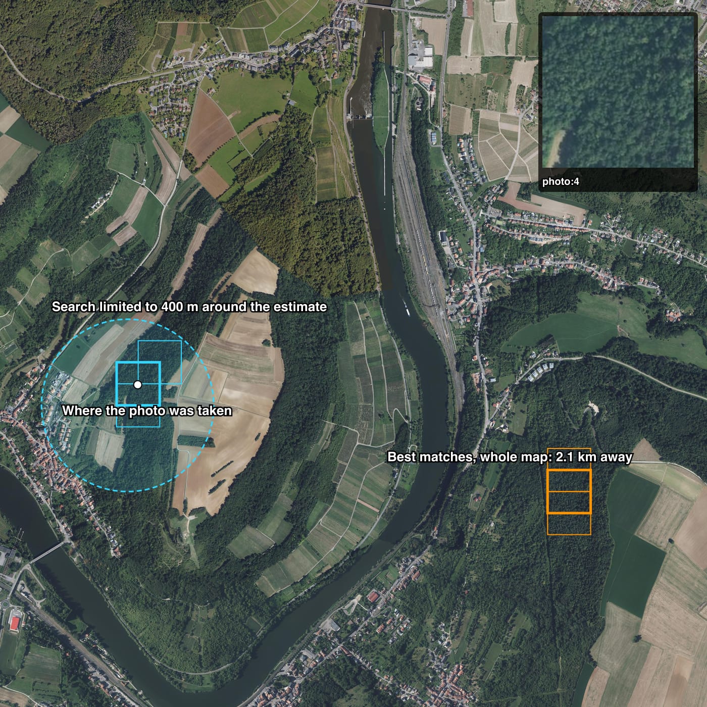
SurrealDB checks the distance condition while it walks the HNSW graph, so tiles outside the radius never take one of the three result places. See filtering through vector search. Here the prior was 107 m from the true position, and the radius of 400 m allows for that error.
Results over 200 photos
The table shows how the two queries performed on 200 photos taken at random positions in the area. Each photo came from imagery of the third date. To match the errors a compass and a barometer leave, each photo was rotated by up to 10°, scaled by up to 15%, and changed in brightness and colour:
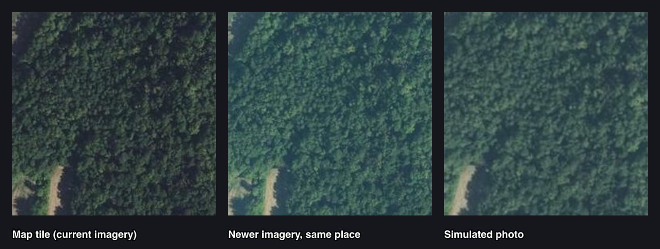
The prior was 150 m from the true position each time.
| Query | Median error | Within 500 m | Country correct |
|---|---|---|---|
| Vector search only | 102 m | 68% | 86% |
| Vector search with a prior | 62 m | 99% | 98% |
The tiles are 100 m apart, so a median error of 62 m is close to the best the grid allows.
Index the tile centres
From SurrealDB 4.0, a SPATIAL index on centre lets the query answer its distance condition from the index:
DEFINE INDEX tile_centre ON tile FIELDS centre SPATIAL;
LET $photo = photo:4.embedding;
LET $prior = photo:4.prior;
SELECT id, centre, country, vector::distance::knn() AS dist FROM tile
	WHERE geo::distance(centre, $prior) < 400
	AND embedding <|3,100|> $photo
ORDER BY dist;The query and its three results are the same as before. The difference is in how SurrealDB finds them. Without the index, the HNSW search checks the distance condition on each tile it visits. With the index, SurrealDB first reads from the index the tiles whose centre is within 400 m of the prior, which is 96 of the 6,962 tiles in the dataset, and the vector search ranks only those. Adding EXPLAIN to the query shows the tile_centre index scan feeding the KnnScan on tile_embedding.
The index matters more as the map grows. A map ten times as wide holds a hundred times as many tiles, but the number within 400 m of the prior stays the same, so the work for each photo stays about the same too.
4. Find which country the drone is in
With a position, an INSIDE check against the borders gives the country:
'FR'The ?? operator handles the river north of the meeting point. A position there is inside no country's polygon, so the subquery returns an empty array, and ?? returns 'LU-DE' in place of NONE:
'LU-DE'5. Plan the next leg
At each position, one query gives the distance to the destination, the direction to fly, and whether the straight route to the destination stays clear of the no-fly zone. $leg is a line from the current position to the destination, which the drone sends as a geometry. At the launch point it is:
{
	bearing: 42.766710281515884f,
	country: 'FR',
	direct_is_clear: false,
	distance: 4999.827558294178f
}
geo::distance() returns metres. geo::bearing() returns degrees from north, positive towards the east, so 42.8 means north-east.
The straight route from the launch point crosses the no-fly zone, so the drone flies to place:waypoint first. The waypoint is across the Moselle from the launch point, south of the meeting point and still in France, and both legs through it are clear:
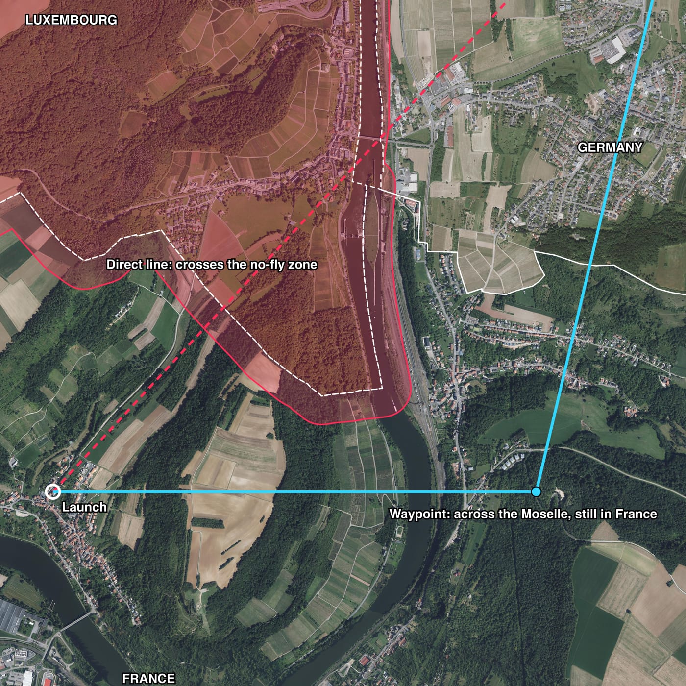
The drone asks the same question at every position, and it changes to the direct route as soon as direct_is_clear is true.
6. Fly the route
The simulated flight repeats one loop every 10 seconds:
Turn into the estimated wind, so the drone moves along the bearing from the last query.
Fly for 10 seconds at 15 m/s.
Estimate the new position by dead reckoning.
Take a photo, and locate it with the prior from step 3.
Update the wind estimate from the gap between the located position and the prior.
Run the leg query from the located position.
A wind of about 3 m/s blows from the south-east, which pushes the drone north-west towards Luxembourg. The drone does not know the wind at the start. It learns it from the photos: each time a photo puts the drone somewhere other than where dead reckoning expected, the difference shows how far the wind moved it. The flight was run twice: once with the photos, and once with dead reckoning only, which cannot learn the wind.
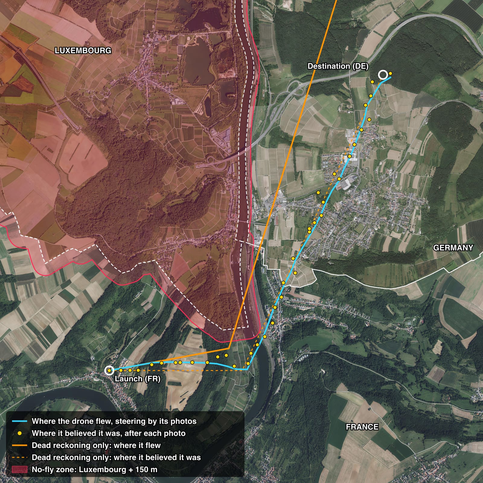
The blue line is where the drone flew, which the drone itself never knows. The yellow dots are where it believed it was after each photo, and it steered by those dots, so the distance from a dot to the blue line is its position error at that moment.
| Run | Steps | Final distance from destination | Largest position error | Steps in Luxembourg |
|---|---|---|---|---|
| With photos | 39 | 104 m | 232 m | 0 |
| Dead reckoning only | 39 | 1,096 m | 1,106 m | 2 |
With photos, the drone flew towards the waypoint for the first 13 steps, then changed to the direct route when the leg query reported it clear. It never entered Luxembourg. With dead reckoning only, the wind carried the drone into Luxembourg while it believed it was on its route, and it stopped a kilometre from the destination when it believed it had arrived.
Run SurrealDB on the drone
This tutorial runs SurrealDB as a server, which is the simplest way to follow the steps. A drone in flight cannot depend on a server. Interference that blocks satellite signals can also block the drone's radio link to the ground, so a drone that asks a remote database for its position loses its position and its link at the same time.
SurrealDB can instead run embedded: inside the drone's own software, in the same process, with no network. An embedded database uses the same query engine as a server, so the queries on this page run unchanged. Each photo is located, each leg is planned and each border is checked on the drone.
The drone needs only the part of the map that its flight plan covers, so it loads that part before take-off:
Map size: this area holds two seasons of tiles in a file of 18 MB. The number of tiles grows with the ground covered, so a square ten times as wide holds a hundred times as many.
Storage: an embedded database can hold the map in memory, or on disk so that it does not have to load again after a restart. See storage engines.
Records written in flight: the drone can store each position it finds as a record, so its route is available after landing.
Limits of the simulation
The demo simulates its photos, and a real flight differs in some ways:
Photos: each photo is a crop of an orthophoto, which is an aerial image corrected so that it looks straight down. A real camera tilts, and its pictures change with altitude and lens.
Heading and altitude: the demo assumes the compass and the barometer still work, so it only rotates and scales each photo by a small error. A drone without a compass would need tiles at several rotations.
Featureless ground: water, large fields and snow give weak matches. The gap between the best and the second-best
distis a measure of confidence, and a real system would trust the dead reckoning more when that gap is small.Grid size: tiles 100 m apart limit the accuracy to about 50 m. Closer tiles give a better position and more records.
Data sources
Aerial imagery: IGN (France), LVGL Saarland (Germany) and ACT geoportail.lu (Luxembourg), each from its open web map service.
Borders: municipal boundaries from OpenStreetMap, © OpenStreetMap contributors, joined into one polygon for each country.
Next steps
Similarity search explains how a
WHEREcondition works during a KNN search.Spatial queries explains the containment and intersection questions that
INSIDEandINTERSECTSanswer.Distance and proximity covers
geo::distance(), and thegeofunctions reference documentsgeo::bearing().